 CosmicLight.com Home
Mars
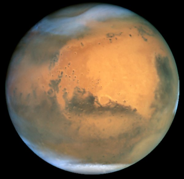
Mars at Opposition in 2001
Acknowledgment: J. Bell (Cornell U.), P. James (U. Toledo), M. Wolff (Space Science Institute), A. Lubenow (STScI), J. Neubert (MIT/Cornell)
Frosty white water ice clouds and swirling orange dust storms above a vivid rusty landscape reveal Mars as a dynamic planet in this sharpest view ever obtained by an Earth-based telescope. NASA's Earth-orbiting Hubble Space Telescope took the picture on June 26, 2001, when Mars was approximately 43 million miles (68 million km) from Earth -- the closest Mars has ever been to Earth since 1988. Hubble can see details as small as 10 miles (16 km) across. The colors have been carefully balanced to give a realistic view of Mars' hues as they might appear through a telescope.
Especially striking is the large amount of seasonal dust storm activity seen in this image. One large storm system is churning high above the northern polar cap [top of image], and a smaller dust storm cloud can be seen nearby. Another large dust storm is spilling out of the giant Hellas impact basin in the Southern Hemisphere lower right].
Hubble had observed Mars before, but never in such detail. The biennial close approaches of Mars and Earth are not all the same. Mars' orbit around the Sun is markedly elliptical; the close approaches to Earth can range from 35 million to 63 million miles. The Mars opposition of 2001 served as a prelude for 2003 when Mars and Earth was to come within 35 million miles of each other, the closest since 1924 and not to be matched until 2287.
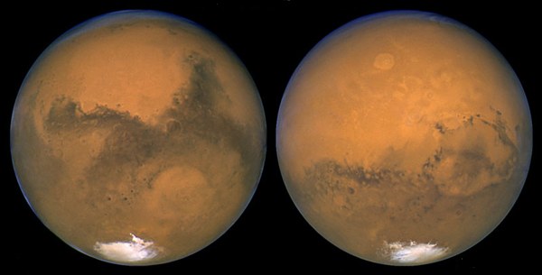
The Two Faces of Mars
Opposition, 2003
These two images, taken 11 hours apart with NASA's Hubble Space Telescope, reveal two nearly opposite sides of Mars. Hubble snapped these photos in August of 2003 as the red planet was making its closest approach to Earth. Mars completed nearly one half a rotation between the two observations.
The image at left was assembled from a series of exposures taken between 6:20 p.m. and 7:12 p.m. EDT Aug. 26 with Hubble's Wide Field and Planetary Camera 2. Hubble snapped this photo when Mars and Earth were 34,648,840 miles (55,760,220 km) apart.
The prominent Martian features in this photo are Syrtis Major, the "shark-fin" shape on the right and the Hellas impact basin, the circular feature near the center of the image.
The image at right was snapped within minutes of the red planet's close rendezvous with Earth, when the two planets were 34,647,420 miles (55,757,930 km) apart. Mars is a mere 1,400 miles closer to Earth in this picture than in the one taken 11 hours earlier. This photo was assembled from a series of exposures taken between 5:35 a.m. and 6:20 a.m. EDT Aug. 27 with Hubble's Wide Field and Planetary Camera 2.
The striking features in this portrait are Olympus Mons [the oval-shaped object just above center], the largest volcano in the solar system and Solis Lacus, an immense dark marking also known as the "Eye of Mars" [below, right].
Both images show most of the southern polar ice cap. The pictures were taken during the middle of summer in the Southern Hemisphere. During this season the Sun shines continuously on the southern polar ice cap, causing the cap to shrink in size [bottom of image]. The orange streaks are indications of dust activity over the polar cap.
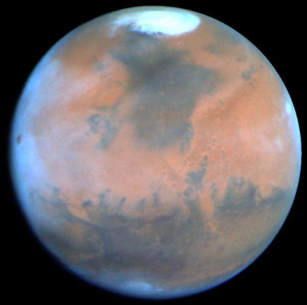
Springtime on Mars
It is spring in Mars' northern hemisphere and much of the carbon dioxide frost around the permanent water-ice cap has sublimated, and the cap has receded to a core of solid water-ice several hundred miles across.
Towering 16 miles (25 km) above the surrounding plains, volcano Ascraeus Mons pokes above the cloud deck near the western or limb. This extinct volcano, measuring 250 miles (402 km) across, was discovered in the early 1970s by Mariner 9 spacecraft. Other key geologic features include (lower left) the Valles Marineris, an immense rift valley the length of the continental United States. Near the center of the disk lies the Chryse basin made up of cratered and chaotic terrain. The oval-looking Argyre impact basin (bottom), appears white due to clouds or frost.
Seasonal winds carry dust to form striking linear features reminiscent of the legendary martian "canals." Many of these "wind streaks" emanate from the bowl of these craters where dark coarse sand is swept out by winds. Hubble resolves several dozen impact craters down to 30-mile diameter. The dark areas, once misinterpreted as regions of vegetation by several early Mars watchers, are really areas of coarse sand that is less reflective than the finer, lighter dust. Seasonal changes in the surface appearance occur as winds move the dust and sand around.
This picture was taken with Hubble's Wide Field Planetary Camera 2 in PC mode. Exposures were taken through three different color filters to create this true color image. The pictures were map-projected onto a sphere for accurate registration and perspective.
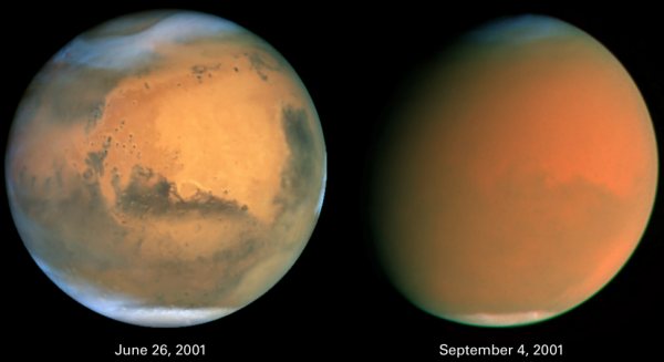
Scientists Track "Perfect Storm" on Mars
Two dramatically different faces of our Red Planet neighbor appear in these comparison images showing how a global dust storm engulfed Mars with the onset of Martian spring in the Southern Hemisphere. When NASA's Hubble Space Telescope imaged Mars in June, the seeds of the storm were caught brewing in the giant Hellas Basin (oval at 4 o'clock position on disk) and in another storm at the northern polar cap.
When Hubble photographed Mars in early September, the storm had already been raging across the planet for nearly two months obscuring all surface features. The fine airborne dust blocks a significant amount of sunlight from reaching the Martian surface. Because the airborne dust is absorbing this sunlight, it heats the upper atmosphere. Seasonal global Mars dust storms have been observed from telescopes for over a century, but this is the biggest storm ever seen in the past several decades.
Mars looks gibbous in the right photograph because it is 26 million miles farther from Earth than in the left photo (though the pictures have been scaled to the same angular size), and our viewing angle has changed. The left picture was taken when Mars was near its closest approach to Earth for 2001 (an event called opposition); at that point the disk of Mars was fully illuminated as seen from Earth because Mars was exactly opposite the Sun.
Both images are in natural color, taken with Hubble's Wide Field Planetary Camera 2.
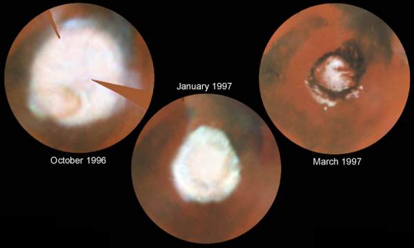
Seasonal Changes in the North Polar Ice Cap
These images, which seem to have been taken while NASA's Hubble Space Telescope (HST) was looking directly down on the Martian North Pole, were actually created by assembling mosaics of three sets of images taken by HST in October, 1996 and in January and March, 1997 and projecting them to appear as they would if seen from above the pole. This first mosaic is a view which could not actually be seen in nature because at this season a portion of the pole would have actually been in shadow; the last view, taken near the summer solstice, would correspond to the Midnight Sun on Earth with the pole fully illuminated all day. The resulting polar maps begin at 50 degrees N latitude and are oriented with 0 degrees longitude at the 12 o'clock position. This series of pictures captures the seasonal retreat of Mars' north polar cap.
October 1996 (early spring in the Northern hemisphere): In this map, assembled from images obtained between Oct. 8 and 15, the cap extends down to 60 degrees N latitude, nearly it's maximum winter extent. (The notches are areas where Hubble data were not available). A thin, comma-shaped cloud of dust can be seen as a salmon-colored crescent at the 7 o'clock position. The cap is actually fairly circular about the geographic pole at this season; the bluish "knobs" where the cap seems to extend further are actually clouds that occurred near the edges of the three separate sets of images used to make the mosaic.
January 1997 (mid-spring): Increased warming as spring progresses in the northern hemisphere has sublimated the carbon dioxide ice and frost below 70 degrees north latitude. The faint darker circle inside the cap boundary marks the location of circumpolar sand dunes (see March '97 map); these dark dunes are warmed more by solar heating than are the brighter surroundings, so the surface frost sublimates from the dunes earlier than from the neighboring areas. Particularly evident is the marked hexagonal shape of the polar cap at this season, noted previously by HST in 1995 and Mariner 9 in 1972; this may be due to topography, which isn't well known, or to wave structure in the circulation. This map was assembled from WFPC2 images obtained between Dec. 30, 1996 and Jan. 4, 1997.
March 30, 1997 (early summer): The cap has fully retreated to its remnant core of water-ice. This residual cap is actually almost cut into two by a large, horn-shaped canyon called Chasma Borealis which is cut deeply into the polar terrain. The HST images also reveal a curious layered terrain which is evidence of past climatic changes on Mars. The sublimation of all of the carbon dioxide has exposed the ring of dark sand dunes which encircle the North Polar Cap. Outliers of ice persist south of the polar sand sea (between the 3 o'clock and 9 o'clock positions). The bright circular features at 3, 6, and 9 o'clock are ice-filled craters.
All images were taken with the Wide Field and Planetary Camera 2. The color is constructed from images taken in red (673 nm) , blue (410 nm) and green (502 nm) light. The resolution at the North Pole ranges from about 115 km/pixel in October '96 to about 45 km/pixel in March '97.
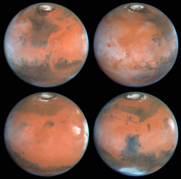
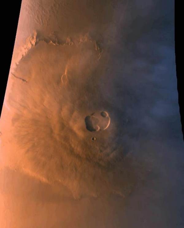
Northern Summer
Four faces of Mars as seen on March 30, 1997 are presented in this montage of NASA Hubble Space Telescope images. Proceeding in the order upper-left, upper-right, lower-left, lower-right, Mars has rotated about ninety degrees between each successive time step. For example the Tharsis volcanoes, which are seen (between 7:30 and 9 o'clock positions) in mid-morning in the upper-left view, are seen near the late afternoon edge of the planet (about 3 o'clock position) in the lower-left image. All of these color images are composed of individual red (673 nanometers), green (502 nm), and blue (410 nm) Planetary Camera exposures.
Upper left: This view is centered on Ares Valles, where Pathfinder will land on July 4, 1997; the Valles Marineris canyon system stretches to the west across the lower left portion of the planet, while the bright, orangish desert of Arabia Planitia is to the east. The bright polar water-ice cap, surrounded by a dark ring of sand dunes, is obvious in the north; since it is northern summer and the pole is tilted toward us, the residual north polar cap is seen in its entirety in all four images. Acidalia Planitia, the prominent dark area fanning southward from the polar region, is thought to have a surface covered with dark sand. Numerous "dark wind streaks" are visible to the south of Acidalia, resulting from wind-blown sand streaming out of the interiors of craters.
Upper right: The Tharsis volcanos and associated clouds are prominent in the western half of this view. Olympus Mons, spanning 340 miles (550 km) across its base and reaching an elevation of 16 miles (25 km), extends through the cloud deck near the western limb, while (from the south) Arsia Mons, Pavonis Mons, and Ascraeus Mons are to the west of center. Valles Marineris stretches to the east, and the Pathfinder landing site is shrouded in clouds near the afternoon limb.
Lower left: This relatively featureless sector of Mars stretches from the Elysium volcanic region in the west to the Tharsis volcanoes (shrouded by the bright clouds near the afternoon limb) in the east. The group of three dark specks just left of center are all that remain of Cerberus, a very prominent dark region during the Viking and Mariner 9 missions. This is an example of the remarkable large scale changes which can occur on Mars due to windblown dust: the former dark area has now been covered by a layer of bright dust, masking the underlying material.
Lower right: The dark Syrtis Major region dominates this image. Syrtis Major is one of the most prominent dark features on Mars, and has been visible since ground-based observers first peered at Mars through telescopes. The bright cloud at 3 o'clock is associated with Elysium Mons. The bright bluish-white feature near the southern limb of the planet is Hellas, a 1,200 mile (2,000 km)diameter impact basin formed by the collision of a large body with Mars long ago. Hellas is covered with dry ice frost and clouds during this season (winter in the south).
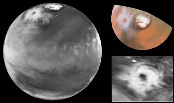
Colossal Polar Cyclone
[left]: The discovery image of the Martian polar storm as seen in blue light (410 nm). The storm is located near 65 deg. N latitude and 85 deg. W longitude, and is more than 1000 miles (1600 km) across. The residual north polar water ice cap is at top. A belt of clouds like that seen in previous telescopic observations during this Martian season can also be seen in the planet's equatorial regions and northern mid-latitudes, as well as in the southern polar regions. The volcano Ascraeus Mons can be seen as a dark spot poking above the cloud deck near the western (morning) limb; this extinct volcano towers nearly 16 miles (25 km) above the surrounding plains, and is about 250 miles (400 km) across.
[upper right]: Color polar view of the north polar region, showing the location of the storm relative to the classical bright and dark features in this area. The color composite data (410, 502, and 673 nm) indicate that the storm is fairly dust-free and therefore likely composed mostly of water ice clouds. The bright surface region beneath the eye of the storm can be seen clearly. This map covers the region north of 45 degrees latitude, and is oriented with 0 degrees longitude at the bottom.
[lower right]: Enhanced orthographic view of the storm centered on 65 deg. N latitude, 85 deg. W longitude. The image has been processed to bring out additional detail in the storm's spiral cloud structures.
The pictures were taken on April 27, 1999, with the NASA Hubble Space Telescope's Wide Field and Planetary Camera 2.
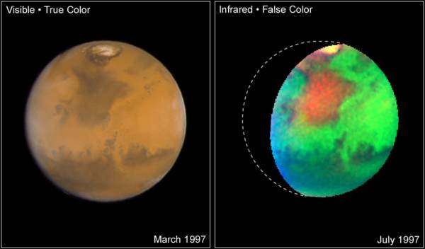
Martian Colors Provide Clues About Martian Water
NASA Hubble Space Telescope images of Mars taken in visible and infrared light detail a rich geologic history and provide further evidence for water-bearing minerals on the planet's surface.
LEFT This "true-color" image of Mars shows the planet as it would look to human eyes. It is clearly more earth-toned than usually depicted in other astronomical images, including earlier Hubble pictures. The slightly bluer shade along the edges of the disk is due to atmospheric hazes and wispy water ice clouds (like cirrus clouds) in the early morning and late evening Martian sky. The yellowish-pink color of the northern polar cap indicates the presence of small iron-bearing dust particles. These particles are covering or are suspended in the air above the blue-white water ice and carbon dioxide ice, which make up the polar cap.
Accurate colors are needed to determine the composition and mineralogy of Mars. This can tell how water has influenced the formation of rocks and minerals found on Mars today, as well as the distribution and abundance of ice and subsurface liquid water. Confirmation of the presence of certain oxidized (rusted) minerals (processed by heat or water action) would imply the possibility of different, perhaps much more Earth-like, past Martian climate periods. Because the smallest features visible in this image are only about 14 miles (22 km) across, Hubble can track small-scale variations in the distribution of minerals that do not follow global trends. The image was generated from three separate Wide Field and Planetary Camera 2 images acquired at wavelengths of 410, 502, and 673 nanometers, in March 1997.
RIGHT A false-color picture taken in infrared light reveals features that cannot be seen in visible light. Hubble's unique infrared view pinpoints variations in the abundance and distribution of unknown water-bearing minerals on the planet. While it has been known for decades that small amounts of water-bearing minerals exist on the planet's surface, the reddish regions in this image indicate areas of enhanced concentrations of these as-yet-unidentified deposits. They are perhaps related to the water-rich history of this part of Mars. In particular, the large reddish region known as Mare Acidalium was the site of massive flooding early in Martian history. (NASA's Pathfinder spacecraft landed at the southern edge of this region in 1997.) This composite image was taken in July 1997 with Hubble's Near Infrared Camera and Multi-Object Spectrometer. Red corresponds to the strength of an absorption band detected near 1450 nanometers; green to the brightness of the surface in the near-infrared; and blue to topographic elevation, determined from Viking Orbiter data.
Researchers: Jim Bell (Cornell University), Justin Maki (NASA Jet Propulsion Laboratory or JPL), and Mike Wolff (Space Sciences Institute), with acknowledgements to Robert Comstock (Central Washington University), Phil James (University of Toledo), and Dave Crisp (JPL) for image processing and acquisition assistance.
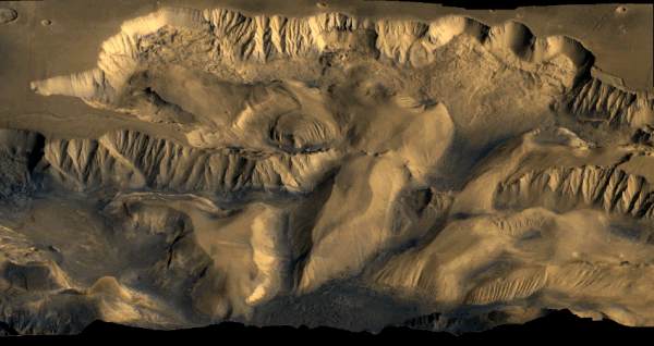
Candor Chasma
Imaged by the Viking Orbiter on December 5, 1978
This is a color mosaic of Viking Orbiter 1 and 2 images showing Candor Chasma, part of the Valles Marineris system on Mars. The oblique view is looking north over the 800 km wide chasm, which is centered at about 6.5 S, 71. W. The walls and floor show evidence of erosion and mass wasting and complex geomorphology.
NASA's Viking Mission to Mars was composed of two spacecraft, Viking 1 and Viking 2, each consisting of an orbiter and a lander. The primary mission objectives were to obtain high resolution images of the Martian surface, characterize the structure and composition of the atmosphere and surface, and search for evidence of life. Viking 1 was launched on August 20, 1975 and arrived at Mars on June 19, 1976. The first month of orbit was devoted to imaging the surface to find appropriate landing sites for the Viking Landers. On July 20, 1976 the Viking 1 Lander separated from the Orbiter and touched down at Chryse Planitia (22.48° N, 49.97° W planetographic, 1.5 km below the datum (6.1 mbar) elevation). Viking 2 was launched September 9, 1975 and entered Mars orbit on August 7, 1976. The Viking 2 Lander touched down at Utopia Planitia (47.97° N, 225.74° W, 3 km below the datum elevation) on September 3, 1976.
The Orbiters imaged the entire surface of Mars at a resolution of 150 to 300 meters, and selected areas at 8 meters. The lowest periapsis altitude for both Orbiters was 300 km. The Viking 2 Orbiter was powered down on July 25, 1978 after 706 orbits, and the Viking 1 Orbiter on August 17, 1980, after over 1400 orbits. (The Orbiter images are available from the National Space Science Data Center on CD-ROM and as photographic products.) The Viking Landers transmitted images of the surface, took surface samples and analyzed them for composition and signs of life, studied atmospheric composition and meteorology, and deployed seismometers. The Viking 2 Lander ended communications on April 11, 1980, and the Viking 1 Lander on November 13, 1982, after transmitting over 1400 images of the two sites.
The results from the Viking experiments gave us our most complete view of Mars to date. Volcanoes, lava plains, immense canyons, cratered areas, wind-formed features, and evidence of surface water are apparent in the Orbiter images. The planet appears to be divisible into two main regions, northern low plains and southern cratered highlands. Superimposed on these regions are the Tharsis and Elysium bulges, which are high-standing volcanic areas, and Valles Marineris, a system of giant canyons near the equator. The surface material at both landing sites can best be characterized as iron-rich clay. Measured temperatures at the landing sites ranged from 150 to 250 K, with a variation over a given day of 35 to 50 K. Seasonal dust storms, pressure changes, and transport of atmospheric gases between the polar caps were observed. The biology experiment produced no evidence of life at either landing site.
Olympus Mons
Imaged by the Mars Global Surveyor
This image of the giant Martian volcano Olympus Mons was taken over a 5 minute period at about 5:30 p.m. local time. Over the time the image was collected the altitude of MGS rose from 176 to 310 km. Olympus Mons is 25 km high and nearly 550 km across. The central caldera is 66 x 83 km in size. The bluish features to the right are water-ice clouds which tend to form around the volcano in the late afternoon. The color was synthesized using red and blue filter images. The image is centered at 23 N, 135 W, resolution of the image is about 1 km and north is up.
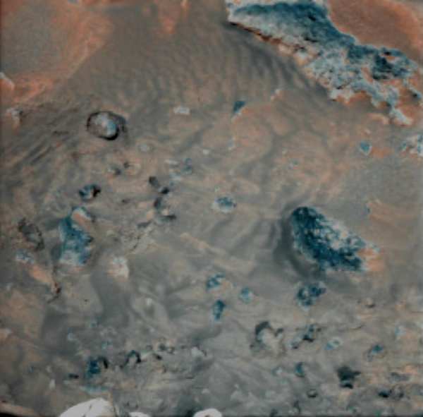
Wind Effects On Martian Soil
Imaged by the Mars Pathfinder Mission on July 31, 1997
This false-color combination image highlights details of wind effects on the Martian soil at the Pathfinder landing site. Red and blue filter images have been combined to enhance brightness contrasts among several soil units. Martian winds have distributed these lighter and darker fine materials in complex patterns around the rocks in the scene (blue). For scale, the rock at right center is 16 centimeters (6.3 inches) long. This scene is one of several that will be monitored weekly for changes caused by wind activity.
Mars Pathfinder was the second in NASA's Discovery program of low-cost spacecraft with highly focused science goals. The Jet Propulsion Laboratory, Pasadena, CA, developed and managed the Mars Pathfinder mission for NASA's Office of Space Science, Washington, D.C. The Imager for Mars Pathfinder (IMP) was developed by the University of Arizona Lunar and Planetary Laboratory under contract to JPL. Peter Smith was the Principal Investigator.
The mission was primarily an engineering demonstration of key technologies and concepts for eventual use in future missions to Mars employing scientific landers. Pathfinder also delivered science instruments to the surface of Mars to investigate the structure of the martian atmosphere, surface meteorology, surface geology, form, and structure, and the elemental composition of Martian rocks and soil. In addition a free-ranging surface rover was deployed to conduct technology experiments and to serve as an instrument deployment mechanism.

Under Martian Clouds
Imaged by the Mars Pathfinder Mission on July 31, 1997
This is the first color image ever taken from the surface of Mars of an overcast sky. Featured are pink stratus clouds coming from the northeast at about 15 miles per hour (6.7 meters/second) at an appoximate height of ten miles (16 kilometers) above the surface.
The clouds consist of water ice condensed on reddish dust particles suspended in the atmosphere. Clouds on Mars are sometimes localized and can sometimes cover entire regions, but have not yet been observed to cover the entire planet.
The image was taken about an hour and forty minutes before sunrise by the Imager for Mars Pathfinder (IMP) on Sol 16 at about ten degrees up from the eastern Martian horizon.
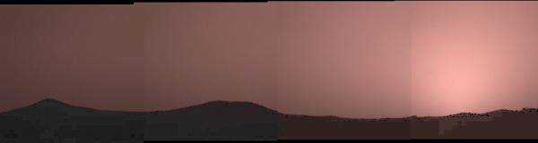
Sunset Over Twin Peaks
Imaged by the Mars Pathfinder Mission on July 31, 1997
This image was taken by the Imager for Mars Pathfinder (IMP) about one minute after sunset on Mars. The prominent hills dubbed "Twin Peaks" form a dark silhouette at the horizon, while the setting sun casts a pink glow over the darkening sky.
The image was taken as part of a twilight study which indicates how the brightness of the sky fades with time after sunset. Scientists found that the sky stays bright for up to two hours after sunset, indicating that Martian dust extends very high into the atmosphere.