Jupiter's Largest Moons

The Galilean Satellites
Ganymede, Callisto, Io, Europa
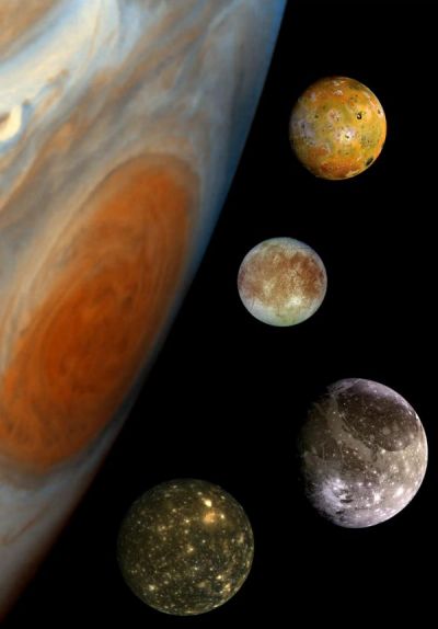
This composite includes the four largest moons of Jupiter which are known as the Galilean satellites. The Galilean satellites were first seen by the Italian astronomer Galileo Galilei in 1610. In order of increasing distance from Jupiter, Io is closest, followed by Europa, Ganymede, and Callisto. North is to the top.
The order of these satellites from the planet Jupiter helps to explain some of the visible differences among the moons. Io is subject to the strongest tidal stresses from the massive planet. These stresses generate internal heating which is released at the surface and makes Io the most volcanically active body in our solar system. Europa appears to be strongly differentiated with a rock/iron core, an ice layer at its surface, and the potential for local or global zones of water between these layers. Tectonic resurfacing brightens terrain on the less active and partially differentiated moon Ganymede. Callisto, furthest from Jupiter, appears heavily cratered at low resolutions and shows no evidence of internal activity.
The Solid State Imaging (CCD) system aboard NASA's Galileo spacecraft obtained the Io and Ganymede images in June 1996, while the Europa images were obtained in September 1996. Because Galileo focusses on high resolution imaging of regional areas on Callisto rather than global coverage, the portrait of Callisto is from the 1979 flyby of NASA's Voyager spacecraft.
Launched in October 1989, Galileo entered orbit around Jupiter on December 7, 1995. The spacecraft's mission is to conduct detailed studies of the giant planet, its largest moons and the Jovian magnetic environment. The Jet Propulsion Laboratory, Pasadena, CA manages the mission for NASA's Office of Space Science, Washington, DC.
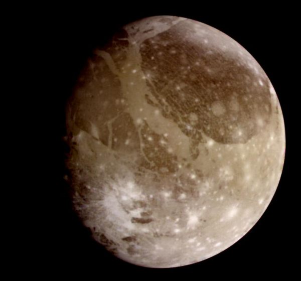
Ganymede, the Largest
Natural color view of Ganymede from the Galileo spacecraft during its first encounter with the satellite. North is to the top of the picture and the sun illuminates the surface from the right. The dark areas are the older, more heavily cratered regions and the light areas are younger, tectonically deformed regions. The brownish-gray color is due to mixtures of rocky materials and ice. Bright spots are geologically recent impact craters and their ejecta. The finest details that can be discerned in this picture are about 13.4 kilometers across. The images which combine for this color image were taken beginning at Universal Time 8:46:04 UT on June 26, 1996.
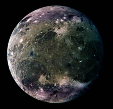
Ganymede's Trailing Hemisphere
In this global view of Ganymede's trailing side, the colors are enhanced to emphasize color differences. The enhancement reveals frosty polar caps in addition to the two predominant terrains on Ganymede, bright, grooved terrain and older, dark furrowed areas. Many craters with diameters up to several dozen kilometers are visible. The violet hues at the poles may be the result of small particles of frost which would scatter more light at shorter wavelengths (the violet end of the spectrum). Ganymede's magnetic field, which was detected by the magnetometer on NASA's Galileo spacecraft in 1996, may be partly responsible for the appearance of the polar terrain. Compared to Earth's polar caps, Ganymede's polar terrain is relatively vast. The frost on Ganymede reaches latitudes as low as 40 degrees on average and 25 degrees at some locations. For comparison with Earth, Miami, Florida lies at 26 degrees north latitude, and Berlin, Germany is located at 52 degrees north.
North is to the top of the picture. The composite, which combines images taken with green, violet, and 1 micrometer filters, is centered at 306 degrees west longitude. The resolution is 9 kilometers (6 miles) per picture element. The images were taken on 29 March 1998 at a range of 918000 kilometers (570,000 miles) by the Solid State Imaging (SSI) system on NASA's Galileo spacecraft.

Morning in Tiamat Sulcus
View of the Tiamat Sulcus region on Ganymede imaged just after local sunrise. The illumination from such a low sun angle highlights the grooved topography of Tiamat. Furrows and fractures are apparent in the surrounding dark terrain also. North-south trending Tiamat Sulcus is divided in two by Kishar Sulcus, which trends east-west. The southern portion of Tiamat is wider than its northern portion, indicating that there has been a greater degree of extension south of Kishar Sulcus than north of it. The portion of Kishar Sulcus to the right of Tiamat Sulcus appears to have slid horizontally (with respect to the left portion of Kishar Sulcus) along a northwest-southeast trending strike-slip fault.
North is to the top of the picture and the sun illuminates the surface from the right. The image, centered at 1 degree south latitude and 204 degrees longitude, covers an area approximately 386 by 387 kilometers. The resolution is 494 meters per picture element. The image was taken on May 7, 1997 at 14 hours, 15 minutes, 7 seconds Universal Time at a range of 48,859 kilometers by the Solid State Imaging (SSI) system on NASA's Galileo spacecraft.
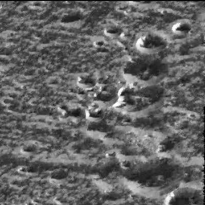
Frost on Ganymede
Scientists believe that water-ice frosts are the likely cause for the brightening seen around the circular rims of these craters located at a high northern latitude (57 degrees) on Ganymede in this image taken by NASA's Galileo spacecraft on September 6, 1996. The image, just recently radioed to Earth from the spacecraft, shows the same kind of bright, high-latitude surface areas as those first seen by the Voyager spacecraft in 1979, but at higher resolution (this image spans about 18 kilometers or 11 miles on a side). Even though the Sun is shining from the
south, the north-facing walls of the ridges and craters are brighter than the walls facing the Sun. This is interpreted to mean that the very bright north-facing slopes are covered with surface water- ice frosts, and that these frosts preferentially accumulate in such high- latitude locations. Galileo scientists say that at the high resolution seen in Galileo images, the high-latitude brightness seen by Voyager is partly attributable to frosts forming on cooler, north-facing slopes.
The right-hand side of the image is dominated by a north-south line of impact craters; the smallest ones at the top are about 2 kilometers (1.2 miles) in diameter and the large one at the bottom is about 5 kilometers (about 3 miles) in diameter. Ganymede is the largest moon in the solar system, larger than the planet Mercury and nearly the size of Mars.
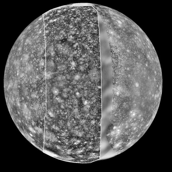
Callisto
This mosaic was prepared from images obtained by three spacecraft: Voyager 1 (left side), Galileo (middle), and Voyager 2 data (right side). The Voyager data were taken in 1979 but left a 'gap' centered at longitude 290 degrees in the trailing hemisphere of Callisto. The Galileo Solid-State Imaging system photographed this area on its second orbit around Jupiter on 9 September, 1996 Universal Time. The resolution of the Galileo data is 4.3 kilometers/pixel (2.7 miles), meaning that the smallest visible feature is about 12 kilometers (7 miles) across. North is to the top of the picture.
Features of interest in the new Galileo data include a dark, smooth area in the northern latitudes (upper third) which appears to mantle older terrain. This could be dark ejecta from a small impact crater. Also visible is a fresh, sharp-rimmed crater some 90 km (56 miles) across named Igaluk (center left third of picture), and a bright zone in the south polar area (bottom of image) which could be an impact scar.

Callisto at Increasing Resolutions
These four views of Callisto highlight how increasing resolutions enable interpretation of the surface. In the global view (top left) the surface is seen to have many small bright spots, while the regional view (top right) reveals the spots to be the larger craters. The local view (bottom right) not only brings out smaller craters and detailed structure of larger craters, but also shows a mooth dark layer of material that appears to cover much of the surface. The close-up frame (bottom left) presents a surprising smoothness in this highest resolution (30 meters per picture element) view of Callisto's surface.
North is to the top of these frames which were taken by the Solid State Imaging (SSI) system on NASA's Galileo spacecraft between November 1996 and November 1997. Even higher resolution images (better than 20 meters per picture element) of Callisto will be taken on June 30, 1999 during the 21st orbit of the spacecraft around Jupiter.
The top left frame is scaled to 10 kilometers (km) per picture element (pixel) and covers an area about 4400 by 2500 km. The moon Callisto, which has a diameter of 4806 km, appears to be peppered with many bright spots. Images at this resolution of other craterred moons in the Solar System indicate that the bright spots could be impact craters. The ring structure of Valhalla, the largest impact structure on Callisto, is visible in the center of the frame. This color view combines images obtained in November 1997 taken through the green, violet, and 1 micrometer filters of the SSI system.
The top right frame is ten times higher resolution (about 1 km per pixel) and covers an area approximately 440 by 250 km. Craters, which are clearly recognizable, appear to be the dominant landform on Callisto. The crater rims appear bright, while the adjacent area and the crater interiors are dark. This resolution is comparable to the best data available from the 1979 flyby's of NASA's two Voyager spacecraft; it reflects the understanding of Callisto prior to new data from Galileo. This Galileo image was taken in November 1996.
The resolution of the bottom right image is again ten times better (100 meters per pixel) and covering an area of about 44 by 25 km. This resolution reveals that some crater rims are not complete rings, but are composed of bright isolated segments. Steep slopes near crater rims reveal dark material that appears to have slid down to reveal bright material. The thickness of the dark layer could be tens of meters. The image was taken in June 1997.
The bottom left image at about 29 meters per pixel is the highest resolution available for Callisto. It covers an area about 4.4 by 2.5 km and is somewhat oblique. Craters are visible but no longer dominate the surface. The image was taken in November 1996.
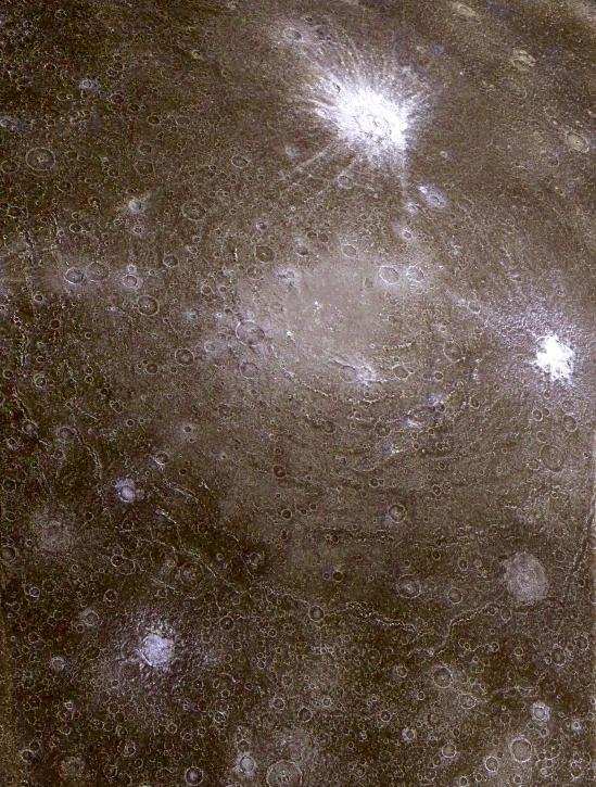
Callisto's Asgard Scarp Mosaic
Low-resolution color data were combined with a higher resolution mosaic to produce this infrared composite image of a pair of ancient multi-ringed impact basins on Callisto. The region imaged is on the leading hemisphere of Callisto near 26 degrees north, 142 degrees west, and is almost 1,400 kilometers (860 miles) across. North is toward the top of the picture and the Sun illuminates the surface from the east. Dominating the scene is the impact structure, Asgard, centered on the smooth, bright region near the middle of the picture and surrounded by concentric rings up to 1,700 kilometers (about 1,050 miles) in diameter. A second ringed structure with a diameter of about 500 kilometers (310 miles) can be seen to the north of Asgard, partially obscured by the more recent, bright-rayed crater, Burr. The icy materials excavated by the younger craters contrast sharply with the darker and redder coatings on older surfaces of Callisto.
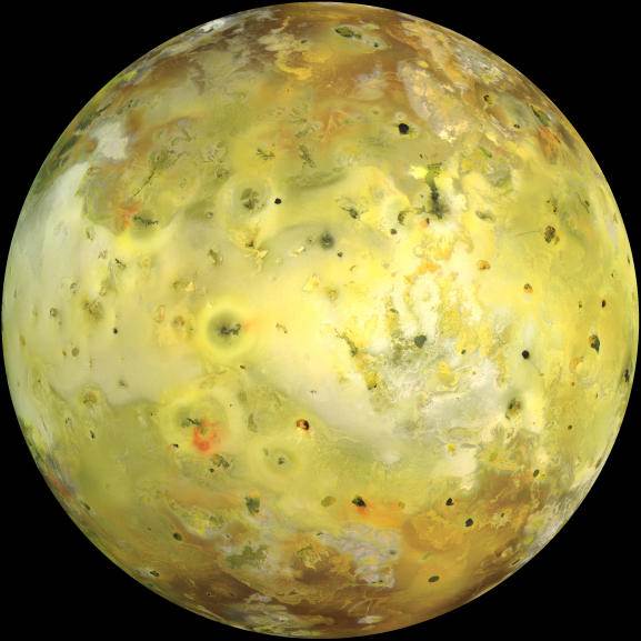
Io
NASA's Galileo spacecraft acquired its highest resolution images of Io on 3 July 1999 during its closest pass to Io since orbit insertion in late 1995. This color mosaic uses the near-infrared, green and violet filters (slightly more than the visible range) of the spacecraft's camera and approximates what the human eye would see. Most of Io's surface has pastel colors, punctuated by black, brown, green, orange, and red units near the active volcanic centers. A false color version of the mosaic has been created to enhance the contrast of the color variations.
The improved resolution reveals small-scale color units which had not been recognized previously and which suggest that the lavas and sulfurous deposits are composed of complex mixtures (Cutout A of false color image). Some of the bright (whitish), high-latitude (near the top and bottom) deposits have an ethereal quality like a transparent covering of frost (Cutout B of false color image). Bright red areas were seen previously only as diffuse deposits. However, they are now seen to exist as both diffuse deposits and sharp linear features like fissures (Cutout C of false color image). Some volcanic centers have bright and colorful flows, perhaps due to flows of sulfur rather than silicate lava (Cutout D of false color image). In this region bright, white material can also be seen to emanate from linear rifts and cliffs.
North is to the top of the picture and the sun illuminates the surface from almost directly behind the spacecraft. This illumination geometry is good for imaging color variations, but poor for imaging topographic shading. However, some topographic shading can be seen here due to the combination of relatively high resolution (1.3 kilometers or 0.8 miles per picture element) and the rugged topography over parts of Io. The image is centered at 0.3 degrees north latitude and 137.5 degrees west longitude. The resolution is 1.3 kilometers (0.8 miles) per picture element. The images were taken on 3 July 1999 at a range of about 130,000 kilometers (81,000 miles) by the Solid State Imaging (SSI) system on NASA's Galileo spacecraft during its twenty-first orbit.
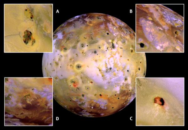
Close-ups in Enhanced Color
NASA's Galileo spacecraft acquired its highest resolution images of Io on July 3, 1999 during its closest pass by Io since it entered orbit around Jupiter in December 1995. This color mosaic uses the near-infrared, green and violet filters (slightly more than the visible range) of the spacecraft's camera, processed to enhance more subtle color variations. Most of Io's surface has pastel colors, punctuated by black, brown, green, orange, and red areas near the active volcanic centers.
The improved resolution reveals small-scale color areas which were not recognized previously and which suggest that the lava and sulfurous deposits are composed of complex mixtures (close-up A). Some of the bright, whitish, high-latitude (near the top and bottom) deposits have an ethereal quality like a transparent covering of frost (close-up B). Bright red areas were seen in previous images only as diffuse deposits. However, they now appear as both diffuse deposits and sharp linear features like fissures (close-up C). Some volcanic centers have bright and colorful flows, perhaps due to flows of sulfur (rather than silicate) lava (close-up D). In this region of Io, bright, white material can also be seen to emanate from linear rifts and cliffs.
North is to the top of the picture, and the Sun illuminates the surface from almost directly behind the spacecraft. This illumination is good for imaging color variations, but poor for imaging topographic shading. However, some topographic shading can be seen here due to the combination of relatively high resolution (1.3 kilometers or 0.8 miles per picture element) and rugged topography over parts of Io. The mosaic is centered at 0.3 degrees north latitude and 137.5 degrees west longitude. The images were taken at a distance of about 130,000 kilometers (81,000 miles) by Galileo's onboard solid state imaging camera.

Volcanic Eruption on Io
This image, taken by NASA's Galileo spacecraft, shows a new blue-colored volcanic plume extending about 100 kilometers (about 60 miles) into space from Jupiter's moon Io (see inset at lower left). The blue color of the plume is consistent with the presence of sulfur dioxide gas and "snow" condensing from the gas as the plume expands and cools. Galileo images have also shown that the Ra Patera plume glows in the dark, perhaps due to the fluorescence of sulfur and oxygen ions created by the breaking apart of sulfur dioxide molecules by energetic particles in the Jovian magnetosphere.
The images at right show a comparison of changes seen near the volcano Ra Patera since the Voyager spacecraft flybys of 1979 (windows at right show Voyager image at top and Galileo image at bottom). This eruptive plume is an example of a new type of volcanic activity discovered during Voyager's flyby in 1979, believed to be geyser-like eruptions driven by sulfur dioxide or sulfur gas erupting and freezing in Io's extremely tenuous atmosphere. Volcanic eruptions on Earth cannot throw materials to such high altitudes. Ra Patera is the site of dramatic surface changes. An area around the volcano of about 40,000 square kilometers, area about the size of New Jersey, has been covered by new volcanic deposits. The image was taken in late June 28, 1996 from a distance of 972,000 kilometers (604,000 miles).
Launched in October 1989, Galileo entered orbit around Jupiter on December 7, 1995. The spacecraft's mission is to conduct detailed studies of the giant planet, its largest moons and the Jovian magnetic environment. The Jet Propulsion Laboratory, Pasadena, CA manages the mission for NASA's Office of Space Science, Washington, DC.

Arizona-sized Eruption
These images of Io show the results of a dramatic event that occurred on the fiery satellite during a five-month period. The changes, captured by the solid state imaging (CCD) system on NASA's Galileo spacecraft, occurred between the time Galileo acquired the left frame, during its seventh orbit of Jupiter, and the right frame, during its tenth orbit.
A new dark spot, 400 kilometers (249 miles) in diameter, which is roughly the size of Arizona, surrounds a volcanic center named Pillan Patera. Galileo imaged a 120 kilometer (75 mile) high plume erupting from this location during its ninth orbit . Pele, which produced the larger plume deposit southwest of Pillan, also appears different than it did during the seventh orbit, perhaps due to interaction between the two large plumes. Pillan's plume deposits appear dark at all wavelengths. This color differs from the very red color associated with Pele, but is similar to the deposits of Babbar Patera, the dark feature southwest of Pele. Some apparent differences between the images are not caused by changes on Io's surface, but rather are due to differences in illumination, emission and phase angles. This is particularly apparent at Babbar Patera.
North is to the top of the images. The left frame was acquired on April 4th, 1997, while the right frame was taken on Sept. 19th, 1997. The images were obtained at ranges of 563,000 kilometers (350,000 miles) for the left image, and 505,600 kilometers (314,165 miles) for the right.

Europa
This image shows a view of the trailing hemisphere of Jupiter's ice-covered satellite, Europa, in approximate natural color. Dark brown areas represent rocky material derived from the interior, implanted by impact, or from a combination of interior and exterior sources. Bright plains in the polar areas (top and bottom) are regions of ice. Long, dark lines are fractures in the crust, some of which are more than 3,000 kilometers (1,850 miles) long. The bright feature containing a central dark spot in the lower third of the image is a young impact crater some 50 kilometers (31 miles) in diameter. This crater has been provisionally named 'Pwyll' for the Celtic god of the underworld.
Europa is about 3,160 kilometers (1,950 miles) in diameter, or about the size of Earth's moon. This image was taken on September 7, 1996, at a range of 677,000 kilometers (417,900 miles) by the solid state imaging television camera onboard the Galileo spacecraft during its second orbit around Jupiter. The image was processed by Deutsche Forschungsanstalt fuer Luft- und Raumfahrt e.V., Berlin, Germany.
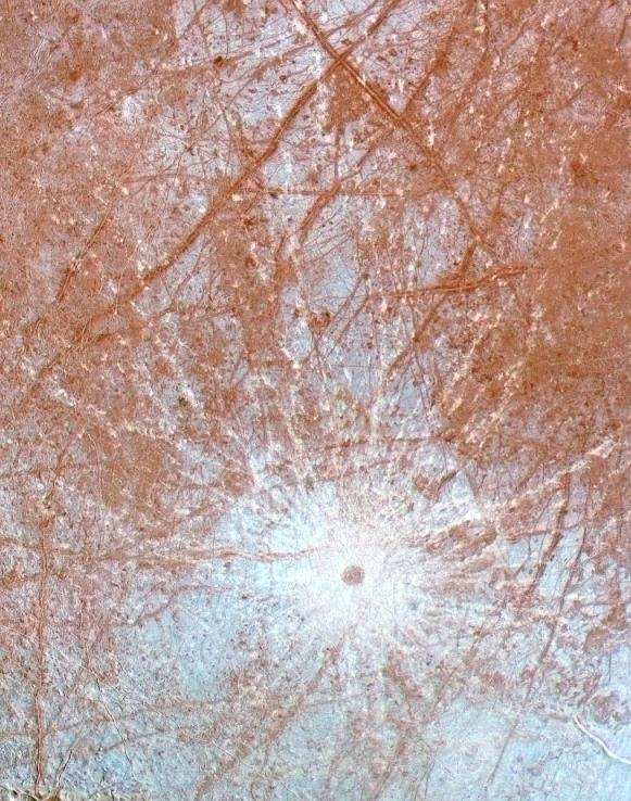
Pwyll Crater
This enhanced color image of the region surrounding the young impact crater Pwyll on Europa was produced by combining low resolution color data with a higher resolution mosaic of images obtained on December 19, 1996 by the Solid State Imaging (CCD) system aboard NASA's Galileo spacecraft. This region is on the trailing hemisphere of the satellite, centered at 11 degrees South and 276 degrees West, and is about 1240 kilometers across. North is toward the top of the image, and the sun illuminates the surface from the east.
The 26 kilometer diameter impact crater Pwyll, just below the center of the image, is thought to be one of the youngest features on the surface of Europa. The diameter of the central dark spot, ejecta blasted from beneath Europa's surface, is approximately 40 kilometers, and bright white rays extend for over a thousand kilometers in all directions from the impact site. These rays cross over many different terrain types, indicating that they are younger than anything they cross. Their bright white color may indicate that they are composed of fresh, fine water ice particles, as opposed to the blue and brown tints of older materials elsewhere in the image.
Also visible in this image are a number of the dark lineaments which are called "triple bands" because they have a bright central stripe surrounded by darker material. Scientists can use the order in which these bands cross each other to determine their relative ages, as they attempt to reconstruct the geologic history of Europa.
Minos Linea Region
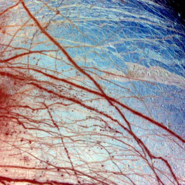
False color has been used here to enhance the visibility of certain features in this composite of three images of the Minos Linea region on Europa taken on 28 June 1996 Universal Time by the solid state imaging camera on NASA's Galileo spacecraft. Triple bands, lineae and mottled terrains appear in brown and reddish hues, indicating the presence of contaminants in the ice. The icy plains, shown here in bluish hues, subdivide into units with different albedos at infrared wavelengths probably because of differences in the grain size of the ice.
The composite was produced using images with effective wavelengths at 989, 757, and 559 nanometers. The spatial resolution in the individual images ranges from 1.6 to 3.3 kilometers (1 to 2 miles) per pixel. The area covered, centered at 45N, 221 W, is about 1,260 km (about 780 miles) across.
Europa Ice Flow
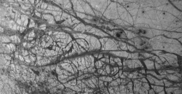
Europa, as seen in this image taken June 27, 1996, by NASA's Galileo spacecraft, displays features in some areas resembling ice floes seen in Earth's polar seas. Europa, about the size of Earth's moon, has an icy crust that has been severely fractured, as indicated by the dark linear, curved, and wedged-shaped bands seen here. These fractures have broken the crust into plates as large as 30 kilometers (18.5 miles) across. Areas between the plates are filled with material that was probably icy slush contaminated with rocky debris. Some individual plates were separated and rotated into new positions.
Europa's density indicates that it has a shell of water ice thicker than 100 kilometers (about 60 miles), parts of which could be liquid. Currently, water ice could extend from the surface down to the rocky interior, but the features seen in this image suggest that motion of the disrupted icy plates was lubricated by soft ice or liquid water below the surface at the time of disruption. This image covers part of the equatorial zone of Europa and was taken from a distance of 156,000 kilometers (about 96,300 miles) by the Solid-state Imaging Subsystem on the Galileo spacecraft. North is to the right and the sun is nearly directly overhead. The area shown is about 510 by 989 kilometers (310-by-600 miles), and the smallest visible feature is about 1.6 kilometers (1 mile) across.
Ice Rafting on Europa
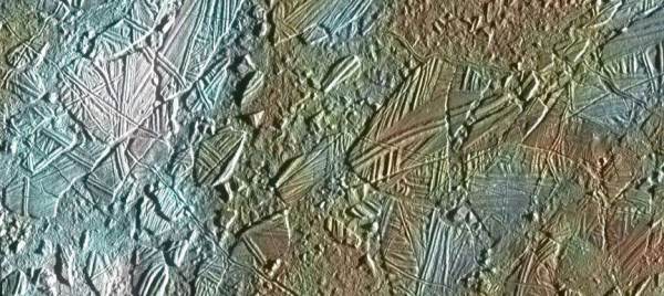
View of a small region of the thin, disrupted ice crust in the Conamara region of Europa showing the interplay of surface color with ice structures. The white and blue colors outline areas that have been blanketed by a fine dust of ice particles ejected at the time of formation of the large (26 kilometer in diameter) crater Pwyll some 1000 kilometers to the south. A few small craters of less than 500 meters or 547 yards in diameter can be seen associated with these regions. These were probably formed, at the same time as the blanketing occured, by large, intact, blocks of ice thrown up in the impact explosion that formed Pwyll. The unblanketed surface has a reddish brown color that has been painted by mineral contaminents carried and spread by water vapor released from below the crust when it was disrupted. The original color of the icy surface was probably a deep blue color seen in large areas elsewhere on the moon. The colors in this picture have been enhanced for visibility.
North is to the top of the picture and the sun illuminates the surface from the right. The image, centered at 9 degrees latitude and 86.5 degrees south longitude, covers an area approximately 70 by 30 kilometers (44 by 19 miles), and combines data taken by the Solid State Imaging (CCD) system on NASA's Galileo spacecraft during three of its orbits through the Jovian system. Low resolution color (violet, green, and infrared) data acquired in September 1996, were combined with medium resolution images from December 1996, to produce synthetic color images. These were then combined with a high resolution mosaic of images acquired on February 20th, 1997 at a resolution of 54 meters (59 yards) per picture element and at a range of 5340 kilometers (3320 miles).
Ancient Impact Basin
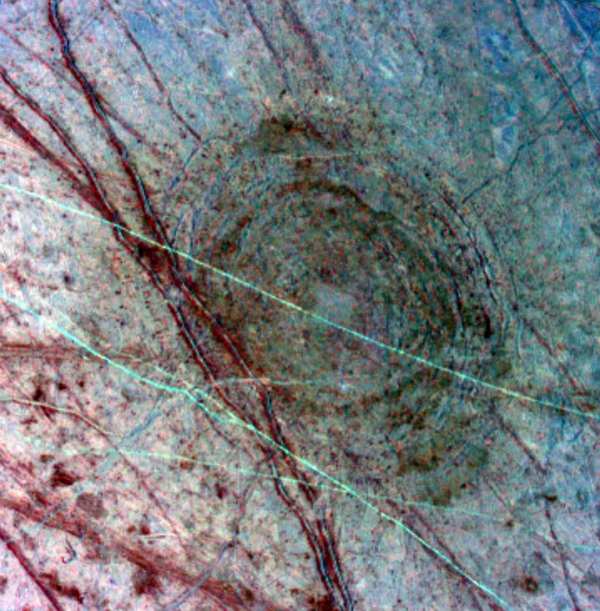
This feature on Europa was seen as a dark, diffuse circular patch on a previous Galileo global image of Europa's leading hemisphere on April 3, 1997. The "bulls-eye" pattern appears to be a 140-kilometer (86-mile) wide impact scar (about the size of the island of Hawaii) which formed as the surface fractured minutes after a mountain-sized asteroid or comet slammed into the satellite. This approximately 214-kilometer (132-mile) wide picture is the product of three images which have been processed in false color to enhance shapes and compositions.
North is toward the top of this picture, which is illuminated from sunlight coming from the west. This color composite reveals a sequence of events which have modified the surface of Europa. The earliest event was the impact which formed the Tyre structure at 34 degrees north latitude and 146.5 degrees west longitude. The impact was followed by the formation of the reddish lines superposed on Tyre. The red color designates areas that are probably a dirty water ice mixture. The fine blue-green lines crossing the region from west to east appear to be ridges which formed after the crater.
The images were taken on April 4, 1997, at a resolution of 595 meters (1950 feet) per picture element and a range of 703,776 kilometers (434,430 miles). The images were taken by Galileo's solid state imaging (CCD) system.
Mosaic of Europa's Ridges, Craters
This view of the icy surface of Europa is a mosaic of two pictures taken by the Solid State Imaging system on board the Galileo spacecraft during a close flyby of Europa on February 20, 1997. The pictures were taken from a distance of 2,000 kilometers (1,240 miles). The area shown is about 14 kilometers by 17 kilometers (8.7 miles by 10.6 miles), and has a resolution of 20 meters (22 yards) per pixel. Illumination is from the right (east). The picture is centered at about 14.8 north latitude, 273.8 west longitude, in Europa's trailing hemisphere.
One of the youngest features seen in this area is the double ridge cutting across the picture from the lower left to the upper right. This double ridge is about 2.6 kilometers (1.6 miles) wide and stands some 300 meters (990 feet) high. Small craters are most easily seen in the smooth deposits along the south margin of the prominent double ridge, and in the rugged ridged terrain farther south. The complexly ridged terrain seen here shows that parts of the icy crust of Europa have been modified by intense faulting and disruption, driven by energy from the planet's interior.
Family Portrait
Jupiter and its Galilean Satellites
 CosmicLight.com Home